

By Indranie Deolall
The dry earth was still booming and vibrating in remote southern Guyana on a blazing Sunday afternoon, but across the Atlantic, it was just after 8 p.m. and freezing, when a top German scientific centre officially reported the rare quake, minutes later.
A monitoring station, the closest, across the border in the tin-mining zone of Pitinga, Brazil, automatically detected the January 31-moderate 5.6 magnitude earthquake that struck at 3:05 p.m., as the seismic waves radiated from the shallow 13-kilometre epicentre in the Rupununi, sending frightened villagers scampering, triggering national astonishment and disbelief, and prompting a chain of rapid reactions from similar sensor sites in South America and further afield. Baffled Brazilians fled their towering and rocking complexes in Manaus, racing down flights of stairs and staying in the streets until the shaking eased.
Ten after-shocks
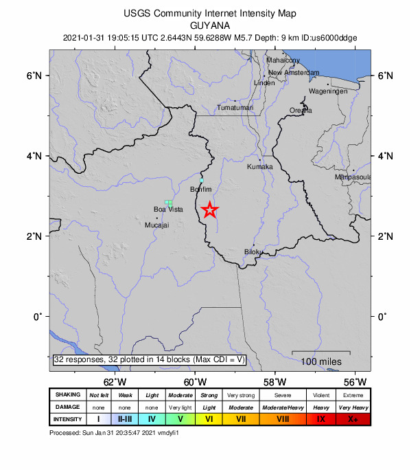
In this country’s modern recorded history, this is likely our first confirmed locally and naturally generated major seismic event. Up to Sunday evening, there were at least 11 aftershocks, measuring between 2.9 and 4.6 in magnitude, with the latter biggest one confirmed Sunday evening, and more expected over weeks, months and even years. The Rupununi earthquake was recalculated by the experts as they studied the incoming flow of information, from 6.0 to 5.9, and finally, 5.6 in magnitude, with the epicentre also corrected by 1.1 km or 0.7 mile towards the south.
Some 1200 stations from nearly 100 seismic networks around the world, help entities like the GFZ German Research Centre for Geosciences keep accurate daily track of the planet’s ever-restless dynamic nature, from the mere baby burp like Sunday’s sudden occurrence, to killer explosions and mega-quakes. Using invaluable data from global partners, the Centre generates dozens of event locations, through its GEOFON programme.
Yet Potsdam, the busy capital and largest city of the German state of Brandenburg could not be more different than the sparsely-inhabited, rolling savannahs, bird-abundant wetlands, thick forests and low mountain ranges of Guyana’s stunning, diversity-rich Region Nine (Upper Takutu-Upper Essequibo).
Black-bellied whistling duck
Originating from the word “rapon” in the Makushi language, for the black-bellied whistling duck found along the meandering river, the Rupununi covers nearly 60,000 square kilometres and has over 80 communities, mainly within the savannah area, including the Dadanawa cattle ranch, the country’s largest and most isolated.
The quake-affected section features small indigenous agrarian villages like Sawariwau, derived from the term “Shawarowaoro” meaning “The Grandfather Spirit of Fishes” in the Pawi shian language, according to the website wapichanao.communitylands.org. Said to be the oldest settlement of the Wapichan people in the Southern Rupununi, it was established in the mid-18th century and is about 70 miles south of the nearby famous frontier town of Lethem and 21 miles east of the Brazilian border of the Takutu River.
A former satellite, Katoonarib, in the South Central, shortened from “Katoonaru Iribi” or “Bush Island” is set on just 68 square miles, but titles to these lands in a vast ancestral homeland named “Wapichan wiizi,” are yet to be granted by the Government to the tribes of Guyana’s original inhabitants, or First Peoples.
Good fortune, lucky geology
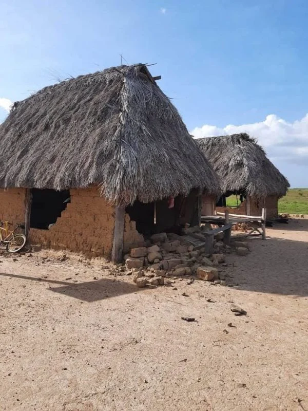
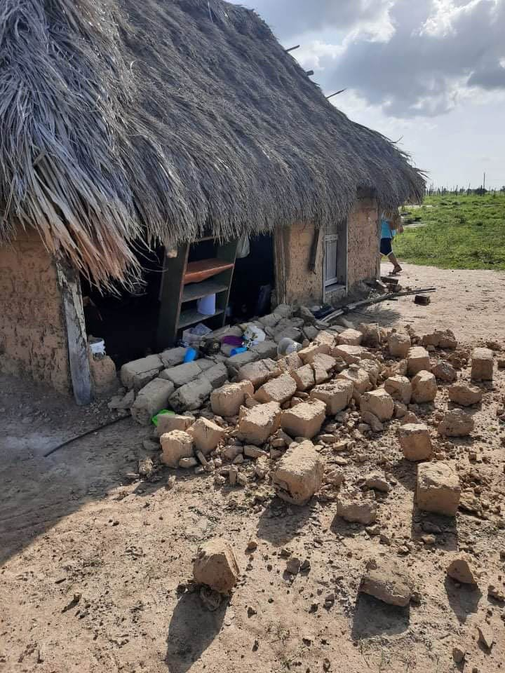
This week, the Civil Defence Commission scrambled to map the secluded location, close to the epicentre, but in assessments by the Regional Disaster Response team on Monday, only two traditional sustainably-built homes of adobe or dried mud blocks, topped with woven troolie leaf-roofs were visibly damaged. Viral photographs from resident Karlos Kroft showed tumbled walls, and a few cracked earth surfaces, as continuing proof of our amazing good fortune and incredibly lucky geology.
“While the team was on the ground, loud rumbling sounds were heard about three times from different directions around the communities. There are no reports of loss of human lives. Residents reported that years ago this sound was (also) heard, and it felt like ‘movement’ of the earth,” the Commission related in a social media post.
Booms and sounds
Small shallow earthquakes sometimes produce these interesting effects or sonic booms that can be heard by people who are very close to them. High-frequency vibrations from shallow earthquakes generate such sounds; when earthquakes are deeper, the vibrations never reach the surface, the United States Geological Survey (USGS) advised.
Reports of unidentified “booms” have emerged from different places around the world for centuries, and although many stories remain a mystery, others were due to human activity, the Survey said.
Hundreds of quakes daily
Improvements in communications and the increased interest in natural disasters mean that the public now learns about earthquakes more quickly than ever. On average, magnitude 2 and smaller earthquakes occur several hundred times a day worldwide, with the truly mega-disasters, of magnitude 8 and higher, about once a year. The U.S National Earthquake Information Center locates about 20,000 earthquakes around the globe annually, or about 55 per day.
The old Richter scale of measurement normally numbered 1-10, is logarithmic so an earthquake of magnitude 5 is ten times more powerful than an earthquake measuring 4. For each step up in magnitude an earthquake releases 30 times more energy. Scientists now use the Moment Magnitude Scale based on the same logarithmic scale but which better gauges the strength of larger earthquakes.
Ancient protective craton
But we are far away from the seismic Rings of Fire that mark the moving tectonic plates that distinguish our perpetually active planet. The ancient geological craton that Southern Guyana and sister states rest on, termed the Guiana Shield really does act as an enduring, protective barrier against earthquakes.
Aged roughly 1.3 billion years, the giant craton is an early, thankfully stable piece of the young Earth’s continental lithosphere, consisting of the two top layers, the crust and the uppermost mantle. The oldest nucleus of South America, it is divided by the Amazon drainage basin into two parts, the resource-wealthy Guiana Shield in the north, and the Guaporé or Central Brazilian Shield in the south.
Rio Branco failure zone
Professor George Sand de França, from the Seismological Observatory of the University of Brasilia, told media- house g1.Globo.com that the earthquake was caused by a geological fault. Failures are fractures in the crust that are under pressure and can move. “In this region, there is a mapped failure zone known as the Rio Branco Failure Zone, which can be a favourable region to undergo movement” he explained.
“This movement is small compared to the movement of the limits of the plates, but enough to generate earthquakes of this magnitude. This tremor was very strong and can reach a radius felt at a distance of 300 km,” he added.
Condo rocking
Business administrator Leonardo Rangel, 29, was with his wife in their 16th-floor apartment of a condominium in the Center-South Zone of Manaus. Around 3:15 p.m., they felt the tremor.
“I was on the couch and I felt dizzy. I thought I was feeling sick. I looked at the chandelier and saw that it was swinging a lot,” Rangel told the television station.
The structure was rocking. “We ran down. We couldn’t get a mask, we even went down barefoot. The recommendation was not to use the elevator, we had to go down the stairs. It was a panic,” he recounted.
It wasn’t nerves
VolcanoDiscovery.com received well over 200 reports from affected Guyanese and Brazilians. Among the submissions was this one from Kwakwani Park, Region 10 (Upper Demerara-Berbice): “I thought something was wrong with me. Until my partner asked if I felt the house shaking, then is when I realised that it wasn’t my nerves.”
*ID tries not to get nervous over the VolcanoDiscovery disclosure that our very own Rupununi earthquake produced the estimated combined seismic energy of 4.46 gigawatt hours, equivalent to 3835 tons of TNT or 0.2 atomic bombs!


